Fabulous Fall Hike – Millbrook Mountain and Gertrude’s Nose, Minnewaska State Park
Overhanging white conglomerate rock slabs at Gertrude’s Nose, Minnewaska State Park.
Just about 100-miles north of Brooklyn, is Minnewaska State Park. Situated along the Shawangunk Ridge, Minnewaska is home to over 23,000 acres of preserved land and is dotted with footpaths, carriage roads and the kind of scenic viewpoints hiking dreams are made of. I first visited Minnewaska as a freshman at SUNY New Paltz and was blown away by the beauty of its lakes and cliff side views across the Wallkill River Valley. Later in college, when I worked there on the maintenance crew, I fell in love with the interior of the park, its numerous waterfalls and rocky ledges, deep crevasses and serene spaces.
Anywhere in Minnewaska is great, but one of my all time faves, and a good introductory hike to the Park, is a 4.4 mile out and back hike to Millbrook Mountain. If time (and your legs) are on your side, a continuation out to Gertrude’s Nose for a 7.1 mile day is a must! It’s a popular park, especially in leaf peeping season, so be sure to arrive early enough to get a coveted spot at the upper parking lot near Lake Minnewaska. Later arrivals will need to park in the lower Awosting lot, which adds add an extra 1.75 miles and 300 feet of elevation gain and loss.

Lake views from the cliff above the east side of Lake Minnewaska. In the late 1800’s through 1970, this spot was home the the Cliff House Hotel.
From the upper parking area, head east (left when facing the lake) and look for the Minnewaska Carriageway, marked with red blazes. This trail leads out in both directions from the parking area, but for now, head east and keep the lake to your right side. While there are views of the lake right off the bat, at .5 in, you will rise up to a flat open expanse atop the white conglomerate cliff side along the eastern edge of Lake Minnewaska. In the heyday of the Victorian Mountaintop Hotel craze, this spot was home to the Cliff House Hotel. I would not blame anyone to simply stop here, have a picnic, enjoy the views and call it a day, but believe it or not, there are prettier scenes to be seen.
Continue south on the red trail until you reach the dam at the far end of Lake Minnewaska. On your left you will find the beginning of the 1.2-mile (also) red-blazed Millbrook Mountain Trail. Here you will leave the crushed stone and gravel of the carriage way, (which also allows for bicycles and horses) and head out onto the footpath in the woods, which is skinnier, rockier and just meant for foot travel.
As you walk away from the lake, you will descend 300 feet over 3/4 of a mile until you reach and then cross over the Coxing Kill (kill meaning creek or body of water in Dutch). After the stream crossing it’s back uphill another half mile to the summit of Millbrook Mountain.

The north-easterly view from Millbrook features Skytop Tower at the nearby Mohonk Preserve.


Looking south-west from Millbrook Mountain.
You’ll know when you reach Millbrook Mountain, because the views open up and the footpath comes to a halt at the cliff’s edge. You have come 2.1 miles in total so far. In front of you is the Wallkill River valley. You can easily spot the town of New Paltz and it’s collection of campus buildings just to the right of downtown, as well as gaze out at the patchwork of apple orchards and farmland. If you’re limited on time, this is your turn around point, but be sure to hang there a bit and watch the hawks as they float there in the sky, taking advantage of the thermal updrafts that help them soar for long stretches without having to flap their wings.
If you prefer a loop to an out-and-back, you may choose to return via the yellow-blazed Millbrook Mountain Carriage Road, which meets the red-trail at the summit of Millbrook Mountain. If you take this route, you will add an additional 1.9 miles to your journey (for a total of 6.1), however it is easier walking than the footpath since this graded terrain was first created for horse and carriage rides. Follow the yellow-blazed Millbrook Carriage Road 1.5 miles until it meets with the also yellow-blazed Hamilton Point Carriage Road. Take a right onto Hamilton and in .4 you will return to the red-blazed Minnewaska Carriage Road, just two tenths to the west of where you turned off originally for Millbrook. From here, hang a left and return to the parking lot via the west and more wooded side of Lake Minnewaska.
For a real treat, given you have the time and the energy, I say hike on from Millbrook & head towards Gertrude’s nose for a 7.1 mile hike. From the summit of Millbrook, hang a right and continue on the new but same-colored red footpath, the Gertrude’s Nose Trail. For the next 1.7 miles you will be walking along mostly level terrain, winding your way nearer and farther away from the cliff’s edge. There are plenty of spots along the way to stop for a snack break, or at the very least an amazing photo op.


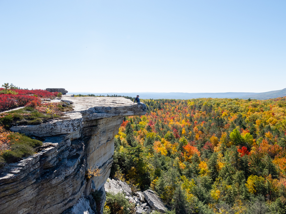
When you come out of the woods and land on big expanses of white rock, with sheer drop offs on multiple sides, you’ve gotten to Gertrude’s Nose. Be sure to use caution here as the crevices between rocks are deep and do keep an eye on the trail markers, as the trail will turn about 315º to the right after reaching the point of Gertrude’s Nose. As before or even more, this is an incredible viewpoint and an amazing place to take some photos for the ‘gram, (or for your Gram!)
If you can tear yourself away to pack up and leave Gertrude’s Nose, you will be turning away from the cliff’s edge that overlooks the Wallkill Valley and instead be walking along the edge of the Palmaghatt Ravine – a drop off on your left hand side, and which you can see across to the other side – a gorgeous site during anytime of year, but especially in fall. There are other Carriage Roads across the divide, which I encourage you to visit on another trip.
In about 1 mile, the red-blazed Gertrude’s Nose Trail will come to an end and meet up with the Millbrook Mountain Carriage Road. Continue straight ahead on the Carriage Road and in a few tenths, you will reach Patterson’s Pellet, a very large boulder, prominently parked on the edge of the Palmaghatt Ravine courtesy of the last ice age. At 1.2 from the start of the Millbrook Carriage Road, you will link up with the also yellow-blazed Hamilton Point Carriage Road. Take a right onto this and in .4, a left onto the red-blazed Lake Minnewaska Carriage Road, returning to your car now via the west and more wooded side of Lake Minnewaska.
Minnewaska State Park is located at 5281 Route 44-55, Kerhonkson, NY 12446. Closing times change with the seasons, but always opens at 9am. Some fabulous and favorite places to refuel post-hike on the north side of the ridge are the nearby Rough Cut Brewing in Kerhonkson and Westwind Orchards in Accord for some fancy wood-fired pizzas. If you’re heading back to the Thruway, there’s the always-classic Mountain Brauhaus in Gardnier and tried and true Bacchus in downtown New Paltz.
Happy hiking, y’all!

Fall is fabulous on the Shawangunk Ridge!!